
|
|
What an amazing period of weather we have had here in N. Ireland during July with a heat wave which lasted almost three weeks when temps peaked at 30 degrees C followed by a big thundery breakdown which produced thunderstorms in the country every single day (and even night) for the last week and a half. I had been out taking advantage of this rare event and had chased on many days for long hours all across Fermanagh, Bundoran, Belfast and Antrim then through mid Ulster to the coast and back so I have been extremely busy. During this period I broke personal records and had already accumulated 1000 miles of chasing and intercepted or experienced thunderstorm activity on 6 out of 9 days so the success greatly out weighed the busts so my spirits were very high. I felt like I hadn't slept much during that entire period from being on the road so often, getting back home very late, then researching forecasts, uploading images, recharging batteries, up early at 07.00 to re-check forecasts, radar, sferics etc then prepare a flask and some snacks then on the road again south to catch more storm action. All the effort was very rewarding for I got to meet good friend and storm chaser Paul Martin from Omagh on several occasions which made the road trip all the more fun. Looking back on that week or more of crazy chases all seems like a dream however the emotional roller coaster ride was having an effect on me, one min we were chasing a severe thunderstorm with green precip core flashing away and loving the structure then the next I would return home to find that the best funnel cloud (possible tornado) in years had formed not far from home on Glenshane Pass. When you have invested a lot of your energy, time and money hunting these things down it can be a hard blow to hear of major action near home when you are 100 miles away, however that's chasing for you.
All the adrenalin and excitement had caught up with me and the loss of sleep was beginning to take it's tole so I was glad to get some rest for a while until I could recover in the hopes of another chase. I never did get that much needed rest because as soon as I let my guard down a big forecast presented itself valid for August 1st/2nd 2013 for all of Ireland and N. Ireland with W areas most at risk. This set-up was so good that ESTOFEX had issued a level 1 risk over the entire country a day in advance for tornadoes, large hail, severe wind gusts and supercell thunderstorms. The media got wind (excuse the pun) of this forecast and the next thing the tornado risk was getting air time on T.V, radio and in the newspapers, this is the first time I have ever heard such a mass interest in the media over a tornado forecast for this country which was surreal. However the media and public don't realize that tornado forecasts are issued many times every year so this in itself was not breaking news. However to storm chasers and photographers this day was of major interest and was in my opinion the most significant thunderstorm set-up for years with incredible potential.
All the models were going for 1000-1600 CAPE with a lifted index between -3 and even -5 in certain areas in the W, these parameters were capable of producing hail stones between 2cm and 4cm in diameter. Furthermore significant vertical wind sheer and turning was overspreading the entire country with extra lift from a lower pressure centre out W over the ocean with the jet stream creating divergence aloft with cold air spreading over the same region. During the Summer time in Ireland we can get the decent CAPE however with little or no shear, however in Winter we can get insane shear but very low CAPE so it's extremely rare to get a synoptic set-up which gave us both decent CAPE and strong shear over such a large area. Forecaster Tony Gilbert from UKweatherworld summed up the potential as follows...
''Atlantic shortwave upper trough continues to influence general lift across UK & Ireland. The combination of low pressure over Ireland with broad high pressure over the continent continues to funnel unstable air from east of Azores. This moist low level advection looks to become notably unstable as a result of solar heating. Relatively strong upper jet stream in place for much of the UK & Ireland with CAPE values expected to extend from surface up to the tropopause over west Ireland. This should give scope for cloud tops to reach great heights resulting in the upper strong winds to be utilised. Lower levels should see ample separation of updraft to downdraft whereby storms will become sustained allowing them to ingest 0-3km shear, fully. End result will likely see a number of Isolated supercells with large hail and isolated tornadoes''.
From a chaser perspective in Ireland this was the kind of forecast dreams were made of, we had potential for tornadoes, funnel clouds, waterspouts at ocean locations, severe thunderstorms, large hail, and supercells. The downside though was the poor visibility, cloud cover, and heavy rainfall amounts which could obscure everything and lead to flash flooding. This was concerning me a great deal, lapse rates inland were poor and needed good solar insolation to generate storms however that did not look likely under all the cloud cover, however W coast areas looked much better so this became the target area of the day. Paul and I were chatting over messages in the morning about what to do and we still couldn't make a decision yet, we didn't want to head off prematurely until we gathered as much information as possible, I was still tired and was not looking forward to that long drive S again and I especially didn't want to be doing it under cloudy skies with rain falling all day, that's no fun at all. In fact, three times during the morning I almost called the chase off as I was getting a bad feeling about the potential, I had seen many exciting days like this before produce nothing and from previous experiences during older chases in skies like today I knew it would be depressing so I really was trying to talk myself out of it, there was another chance of storms the following day with 1500 CAPE in a post frontal air mass with better visibility so I was tempted to save money and try that day instead closer to home however something kept telling me to forget about that and focus my attention on today.
This was a high risk day, by that I mean there was a high risk of nothing happening however if something did happen then there was also the high risk of something amazing being caught on camera so I reluctantly decided to go. I thought to myself if I'm not in I can't win, I have taken countless risks for years with this thrilling passion and I know that when the rewards come they are worth it. I also believe that one has to show nature that you are dedicated and serious and if you show her this then she will reward you when you least expect it. After all the recent chases and other photo shoots during June I felt I had earned my rite of passage and was ready for something special. It was time to ignore the negatives and focus on the positives, the major positive was already visible on the Sat images when I was up at 07.00, a huge storm was located to the far SW of Ireland over the ocean with other storms trailing it, the anvil on this thing was gigantic and bigger than N. Ireland, radar showed red echoes and lightning and as it slowly moved N over the ocean it seemed to grow bigger, it was obvious this was a very well organized storm cluster called a Mesoscale Convective System or MCS and this could approach the shores of Ireland in the evening so this became one of our targets. Before this though there was a large mass of very intense rainfall moving up the country from S to N so I knew we would have to punch through this and wait out down S and hope visibility improved for afternoon and evening storms.
I packed some lunch, two flasks, water, put extra fuel in the car and drove off into a horrible grey sky with rain and drizzle which looked more like a Winter's day pea soup frontal system from the Atlantic. I have to say it was not an inspiring sight and my alarm bells were ringing, I couldn't face a bust today in these conditions so far from home so I asked the universe out loud to present us with something very special, I had put it out there, now I had to have faith in nature, the forecast, and our own instincts. I drove through Cookstown then into Omagh where I met up with Paul Martin but before heading straight S we decided to re-check everything online so we used Paul's home computer to have another look at the situation. Skywarn UK had issued a severe thunderstorm warning for W areas and the sferics charts showed lightning strikes across the W. Donegal coastline and the coast of Galway, these strikes were associated with cells embedded within the warm sector and couldn't be seen visually until encountered so they could happen just about anywhere.
Then an image appeared on the forums taken just 14 min's earlier of a beautiful waterspout over the ocean near Galway, Paul and I nearly jumped for joy, we were thinking if that's happening already then this day is for real and more could spin up anywhere so we quickly had a brew then hit the road again. We found out later that this image was a fake, a business owner had photoshopped a waterspout from the USA onto an image taken from Galway that morning and passed it off as real until someone caught him out. The person did this to promote their own business and even got an undeserved full newspaper write up, I have to say this person should be ashamed of themselves and what they did was throw more distrust upon photographers like us, this guy should have been banished in public and his business should suffer because of his deceit and lies, it's a good job we didn't know it was fake at the time though because that one image was our main source of motivation to keep going so perhaps in a way I should thank him.
We left Omagh, went through Kesh, entered Fermanagh and did a quick stop for another radar check beside one of the great lakes. It was still raining however we could make out embedded convection and large dark areas in the grey which could have been cells. We drove on to Belleek then crossed the border into Bundoran. As we where driving along the main street Paul said wouldn't it be funny if we bumped into chaser Tyler Collins who earlier on facebook said he would be chasing this day and that he might end up in Bundoran, Paul also asked if he was driving a jeep?, just as he said this a red jeep passed us in the middle of town, it was Tyler and friend Clayton Harkin and they beeped the horn when they saw us - what an incredible coincidence!. We all parked up at the edge of town and had a chat about the situation, the map was out so we could study potential target areas based on the last radar update, we still felt sure of hitting the coastline to the W where we could watch across the ocean for waterspouts.
We were starving though so Paul and I walked into town and had a very tasty chicken fillet burger meal in a sit-in fast food shop, we had the feeling we were going to be very busy all evening and wouldn't have time for eating later so we were better off using this quiet period to eat and get fueled up for what could be a long evening ahead. As we were eating the radio was playing with chat about tornadoes today in Ireland which yet again was surreal to hear. Paul got mobile internet coverage and did another check, when he asked me to look at the screen I almost dropped my fries on the floor for their was a stunning image of a large white funnel cloud rotating over a building captured over Shannon and posted only 4 min's ago, holy c**p that was an awesome catch and the cell/cluster which had produced it was away S and heading N up this direction within the next hour so we threw back the rest of the fries and coke and walked briskly back to the car and informed Tyler and Clayton of the news.
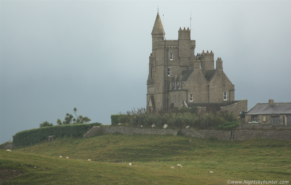 |
So two car loads of us hit the road with the intention of intercepting that funnel-producing cluster. Paul did a stunning job navigating using the map and a mental image of the radar and placed us at an excellent elevated location below the border called Mullaghmore in Co. Sligo which was an isolated and beautiful outcrop of the coast with excellent views across the Atlantic Ocean to the W and NW which was perfect for what we needed. I spotted this stunning castle on a hill in the distance which really got my attention, it looked like something from Transylvania, I am a big fan of ancient locations and castles so I couldn't resist getting an image just incase nothing else happened today so at least I would have some memory to take home with me. Excuse the poor light, it was taken with the telephoto lens at 400mm while it was raining with hazy sunshine breaking through the drizzle. This castle is called 'Classie Bawn', it has a fascinating history and a dark past too however it is now privately owned so the public can't get anywhere near it which is unfortunate as I would have loved to have got some images up close and personal. This is what I love about photography and storm chasing, you never know where you are going to end up and you never know what you are going to see, I had researched Castles in Ireland before however for some reason I had missed this beauty so this was a nice treat indeed and perhaps a good omen of better things to come.
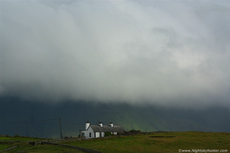 |
There was so much moisture at low levels that great ground hugging formations of white cloud and fog moved over the hills and mountains which were quite dramatic to watch. This lonely Irish cottage looked cool dwarfed by the clouds above, you can really sense the isolation in this scene which I like along with the single thick shaft of sunlight lighting up a portion of the steep mountain behind.
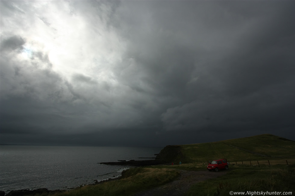 |
The cell which had earlier produced the white funnel over Shannon then passed over us, no thunder, no lightning, no funnels, just heavy rain and grey skies as before, however as it moved off into the distance the back edge of the cell had some structure which eventually evolved into a dark lowering base as it moved N towards Donegal, here it is at 10mm, this was the first storm structure we had seen all day. You can see Tyler's red jeep below with Tyler and Clayton exploring the shoreline for photography, they were going to have a BBQ so Paul and I moved another half mile around the coast to a better vantage point so we could monitor that departing cell in case there were funnels.
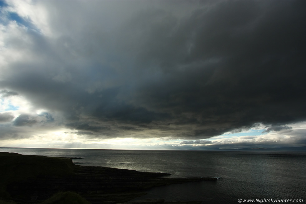
It didn't produce anything and the sky looked pathetic with entirely none convective clouds on view then the sun came out and teased us, if only it had been out earlier then we may have had storms. Paul did another radar check and our hopes were dashed when it showed no cells over the country at all and no lightning, this was looking like a major bust day and our spirits dropped big time. However the radar did show stunning cells far away over the ocean approx 100 miles distant, these were massive in size and training in a line over the sea to our SW, they where moving S to N so they could come into view later on however they where just too far away and would not come anywhere near the shore, there was no question that those ocean cells were meant to be our storms however a change on the positioning had kept them far from land so all we could do was sulk. We observed the tops of the leading edge of these storms far away to the SW and we could tell they were serious cells which were going crazy, we joked about hiring a boat to get closer to them. Paul and I had a mug of tea and not much was said as we were both thinking this has been one hell of a let down, we both felt frustrated, angry and let down by nature however neither of us voiced these thoughts out loud as we didn't want to bring any negative energy upon us.
 |
Something of interest happened to keep us occupied for a while. We watched in amazement as a large and highly textured elevated updraught base actually formed rite over our heads, Tyler and Clayton then joined us to watch, this was interesting because we could see other clouds blowing rapidly in the high shear from S to N however clouds feeding into this never seemed to move away, in fact, they all seemed to congregate in this one area and merge together into this base which then parked itself over the sea in front of us, this was a classic example of convergence at work, it was almost like a spaceship hovering in the sky and for a period it took on a very well rounded profile much like the base of a mesocyclone forming. We even observed several instances of cloud tags/scud lifting under the base with clear turning/slow rotating motion which we hoped was about to form into a funnel however despite teasing us with interesting shapes it never gave us the trophy. It was difficult to shoot being backlit by a high sun. Just when we thought this could be a big cell growing which would save the day it decided to stop hovering and drift off into the distance where it produced precip and died, it was clear it was organising at the base but struggled aloft with no decent tower to complete the process.
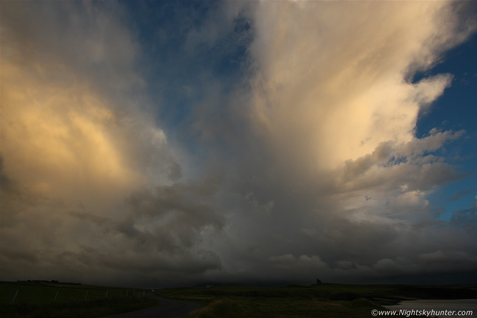 |
All four of us had been standing on this cliff for hours and were getting cold and tired. Tyler and Clayton decided to move on and chase to Letterkenny while Paul and I remained at Mullaghmore. We drove back around to our original position and spotted some nice convective clouds lit by the setting sun approach us from the S, a quick radar check revealed a sizable cell with red echoes so this was it heading for us. We got no sferics from it however it did put on quite a show with the entire convective mess lit up into strange fiery colours, here it is as it got closer at 10mm ultra wide angle, you can see two large towers/anvils heading this way, the R anvil is well sheared downwind and even in this ultra wide shot it still extended out of frame and overhead with its ice crystal rich anvil lit into a wonderful gold colour, you can see the dark form of Classie Bawn castle to the lower R for a sense of scale.
The sun set and the sky darkened into an eerie blue colour, it was overcast with light rain so we decided to use the chance to get another brew. It turned out that the water was cold in both my flasks, our food was more or less done and we had run out of drinking water. We where in the middle of nowhere in the dark and the shops were already closed so we had to wait it out with no basic comforts which was bit of a downer. In the darkness a Priest walked past the car with his dog and was gone, then it rained again and it seemed like sitting here was the worse place in the world. We both felt exhausted and knew that sitting here was just delaying the inevitable, the truth was that this was an awful bust and we should never have left home, now we where parked here in the Republic feeling tired, cold, thirsty and beaten, we just wanted to appear back in our own homes without the thought of the awful long drive back home in the dark.
Yet despite all these feelings looming in the background we both felt that we should not leave, our instincts were telling us to stay put and be patient and to not give up, after all we didn't come all this way to come home empty handed with our tails between our legs, we decided that we where here so we will stay here and see what happens, maybe the sky would clear and we could get a late season NLC display, if not, then some star shots over the ocean, it didn't matter as long as we got something to justify our road trip and the chances of something cool happening were high because every time Paul and I meet something always happens. Then we recalled those cells we had seen on radar earlier, despite being a vast distance from us there was a chance we might see a flash once the sky darkened so we decided to hold on to this glimmer of hope and wait, and wait, and wait some more.
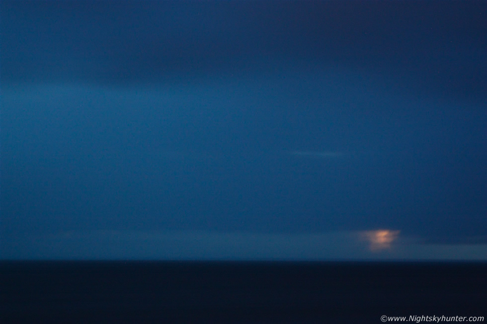 |
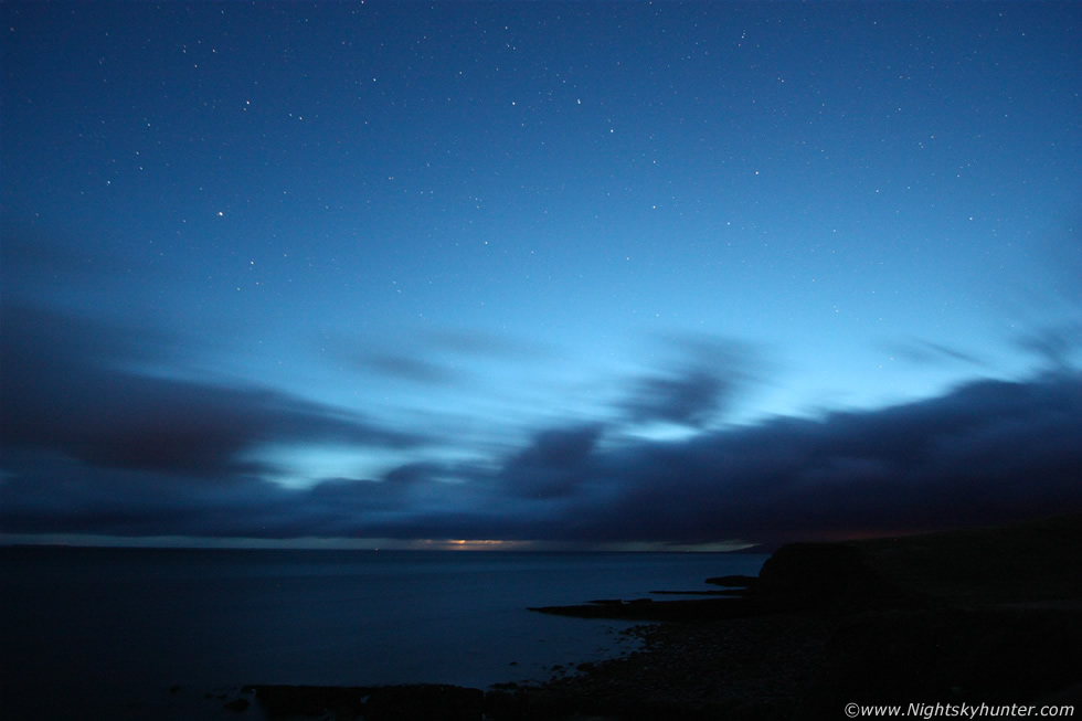
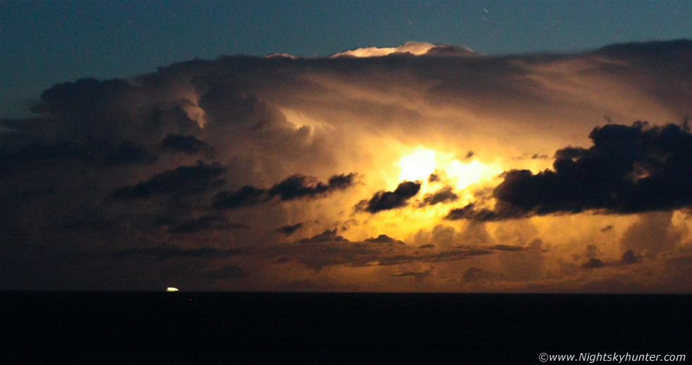
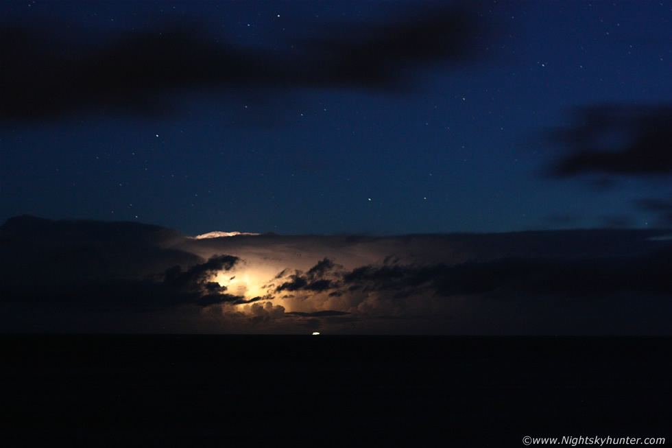
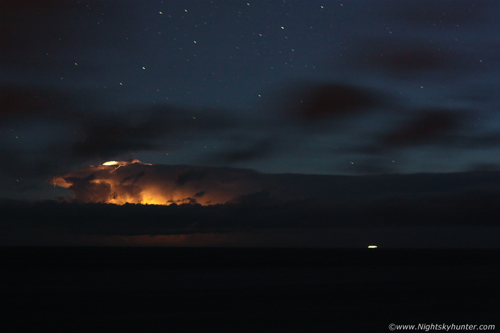
Dusk at the ocean, we where sitting in the car starring out the rain soaked windows towards the sea hoping for something of interest, I have to admit I felt like I was conning myself yet I couldn't shake the feeling that something good was going to happen. The rain stopped and the clouds began to break to reveal a moody dark blue dusk sky so Paul and I got out from the car to stretch our legs when suddenly I saw a bright flash of lightning on the ocean horizon directly in front of me!, I informed Paul however he was thinking what I was thinking, perhaps it was wishful thinking or the light from a distant ship, then as if in answer to our silent question another flash lit up the sky to the R of the first followed by another to the L, that got our attention, we ran back to the car and set up the tripods and got the cameras mounted, we didn't have much time as another shower was approaching us from the S and moving in so we had maybe 5 min's before we lost the horizon.
Our brains had to make some very fast decisions when it came to lenses and settings and time was something we didn't have with that cloud getting closer. I attached the Canon 24-70mm F/2.8 lens, stopped the lens down and began taking exposures at 70mm, Paul was doing similar with the wide angle. Lightning flashed again, then another, jeez the activity was really picking up fast. We both decided that if we could catch just one flash on camera then we could be happy and call it a night. Another lightning bolt flashed at image centre and it didn't show up on my camera, darn it, maybe they where just too far away, however I changed my strategy, there was no need to stop down at this distance, light and sensitivity was the key so I opened the aperture wider, put up the ISO and did a longer exposure, next flash I got!, that's it in the above image. It may not look like much however I was jumping for joy, Paul caught one too and as we examined each other's LCD screens more bolts lit up over the ocean, I figured that once the sky got darker we could be getting some serious action.
 |
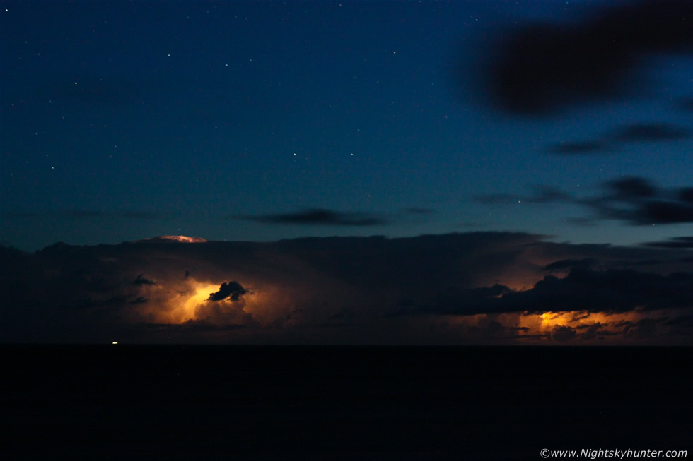
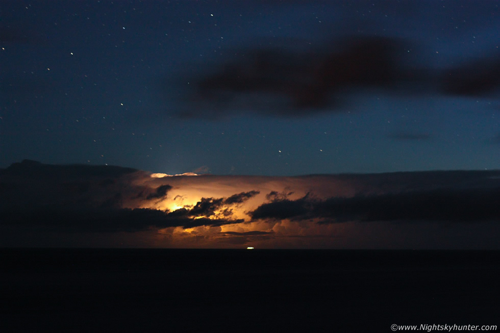
This was two bright flashes in the same frame with the 70mm, you can see how distant those storms are, all the orange and yellow colours in these images is from lightning. The dark clouds running across the image are foreground convection blowing through and not associated with the distant storms.
 |
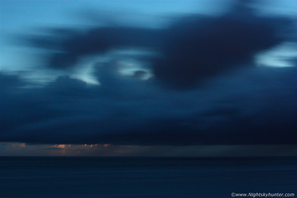
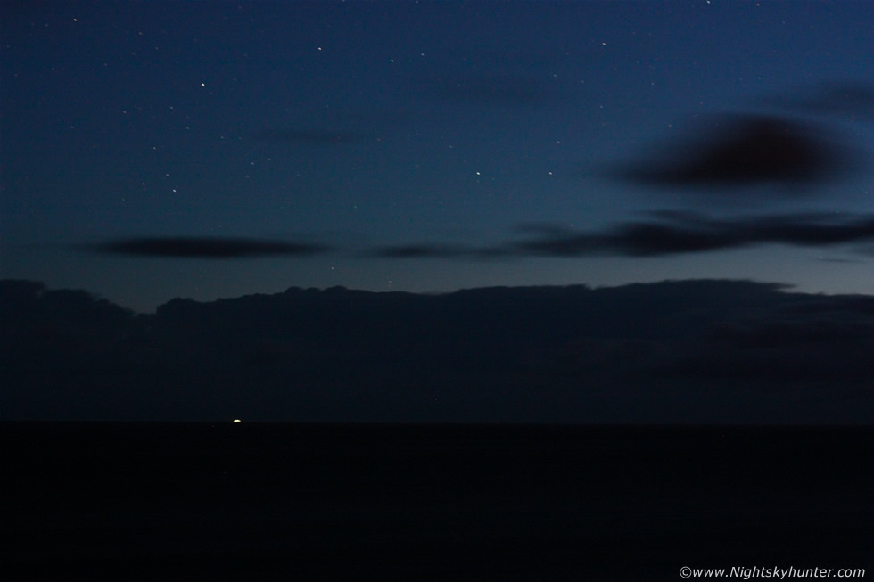
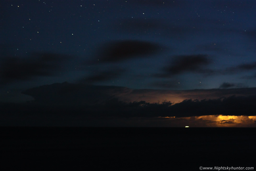
The rain from the S seemed to side swipe us as it approached and the clouds fell apart behind us so we didn't have to pack away the gear at all, luck was now on our side. The sky began to clear rapidly as residual cloud thinned out then the first stars of the night were on show. This is a 10mm ultra wide shot with lightning flashes, I was going this wide to try for sprites for a laugh.
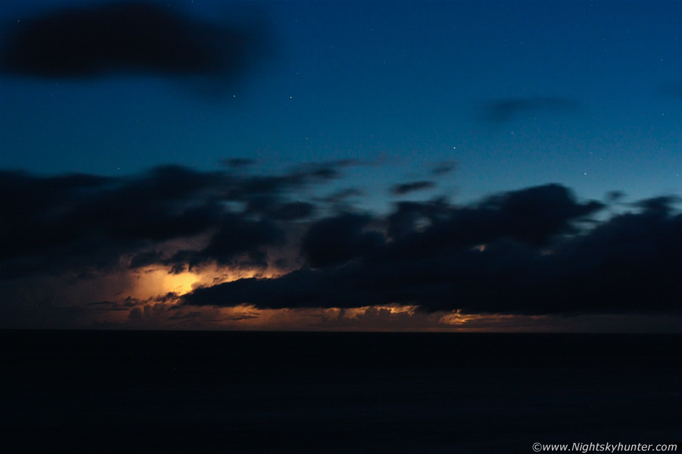 |
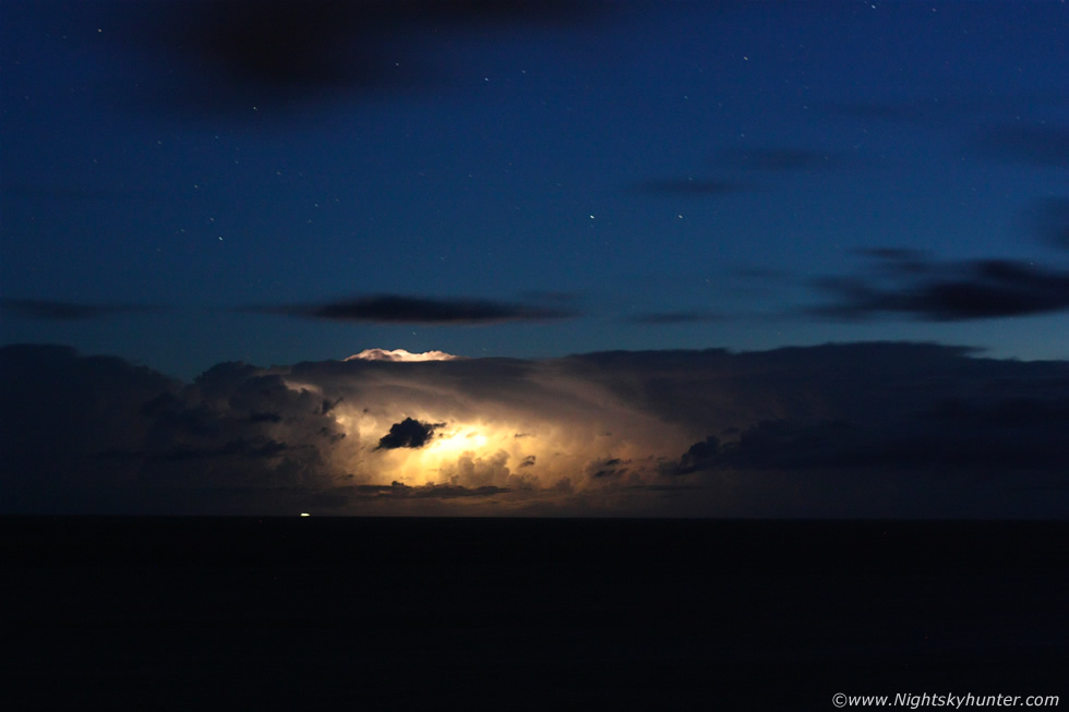
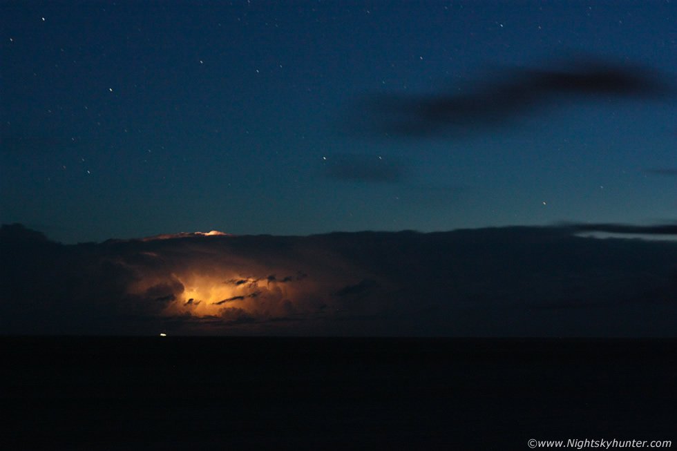
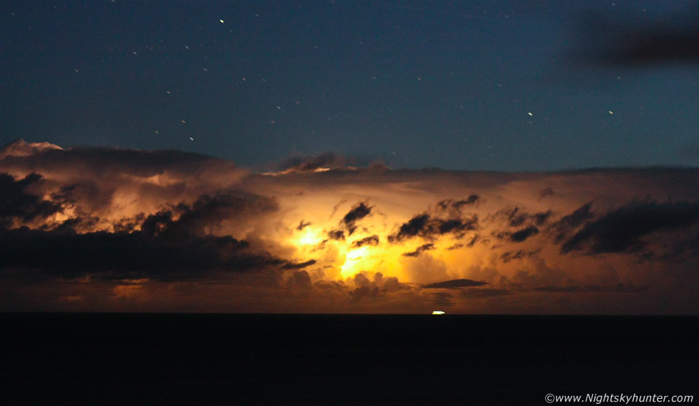
This was when it hit us that a major lightning show was unfolding directly in front of us. Those cells we had seen over the ocean earlier on radar where now sitting in a N-S line +80 miles away over the Atlantic Ocean sporting red and white radar reflectivity meaning the storm's precip out put was at the top of the scale. These were truly severe and highly organised storms of massive size, the line of storms was so long that it's vertical length (as seen from above) was the same length of Ireland itself. They where actually so distant that they were almost outside radar coverage with only the E sides of the storms getting detected, when you can consider that the closer cells where 80 miles distant and the cells behind these (we could see flashes from these) where further away still then for the cells and lightning to be seen so vividly from here must indicate truly massive storm clouds at the top of the Troposphere. The sky was lighting up like a Christmas tree now with lightning firing from cells to the W and NW of our location. I switched to the Canon 50mm F/1.8 to collect as much light and with as much speed as possible and began shooting, Paul and I where now in the zone and nature took over the show, the daylight bust was soon forgotten as an epic lightning show erupted over the Atlantic.
 |
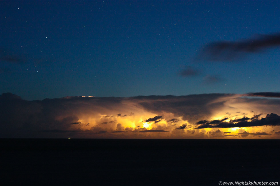
Line of severe thunderstorms 80 miles away off the W coast of Ireland, my goodness we were impressed with Mullaghmore, this was our first time chasing here and it was already presenting us with the finest lightning display we had both ever seen. The display we witnessed over the next two hours was truly stupendous, it was without question the most exciting storm event we have ever seen and to be honest it was actually the stuff that storm chasers dreams were made of. I had observed amazing night time lightning shows before in N. Ireland during 2008, 2006 and 2005 not to mention the incredible storms of 1985, these where all close range overhead events associated with intense rainfall however this was a different scene altogether for we had an epic lightning display at night complete with storm structure, surrounded by stars, and over an ocean horizon, from a storm photographer's point of view this was utter perfection. Here's a bright in-cloud flash which lit up the storm from within, the storms where moving from L to R in all these images and that white light below is from a distant fishing vessel.
 |
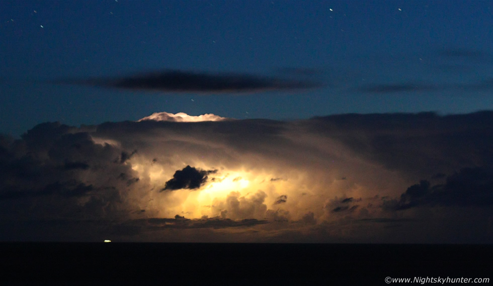
Lightning was almost constant at this stage, we could see flash after flash from three storms, at first the lightning was a soft flash then suddenly it got very bright and well defined with remarkable motion visible throughout the cells. Paul and I can recall this moment, we were exposing and looked up at the same time and saw 5 lightning bolts light up the inside of this storm cluster, the individual bolts shot horizontally across the storm from R to L like a whip of yellow-orange light that transversed the entire length of the storm in sec's, it was a jaw dropping sight which got greeted by loud yells of excitement from us. We were buzzing big time and our adrenaline was pumping, there was so much action going on that there was little time for chat as we were both caught up in our own world of photography while trying to observe the action visually at the same time. Many anvils are visible here and rapid back-building updraughts at the rear which became new cells.
 |
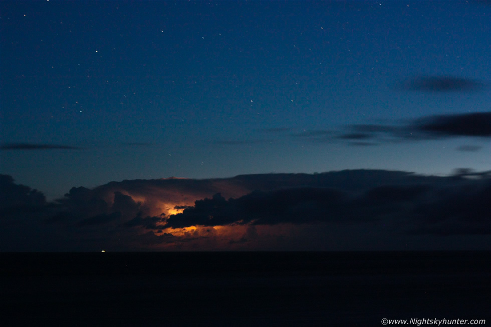
This is a crop from another 50mm frame of that massive storm. The huge size, the overshooting top, solid cloud edges and sheer vertical sides of this structure are a testament to its severity not to mention the highly electrified nature of this beast, this was bloody awesome and we were loving every second of it. Check out the ship for a sense of scale, they must have had an amazing show from their position, perhaps even a frightening experience from that range, they where the closest humans to the storms in the country this night. The above image captures another multiple lightning burst which was so bright it burned out in the short exposure. There would be severe weather going on under these storms with heavy rain, possibly large hail, powerful downdraughts with lightning with a real risk of strong waterspouts/tornadoes, any ship would have been wise to stay clear of these storms.
 |
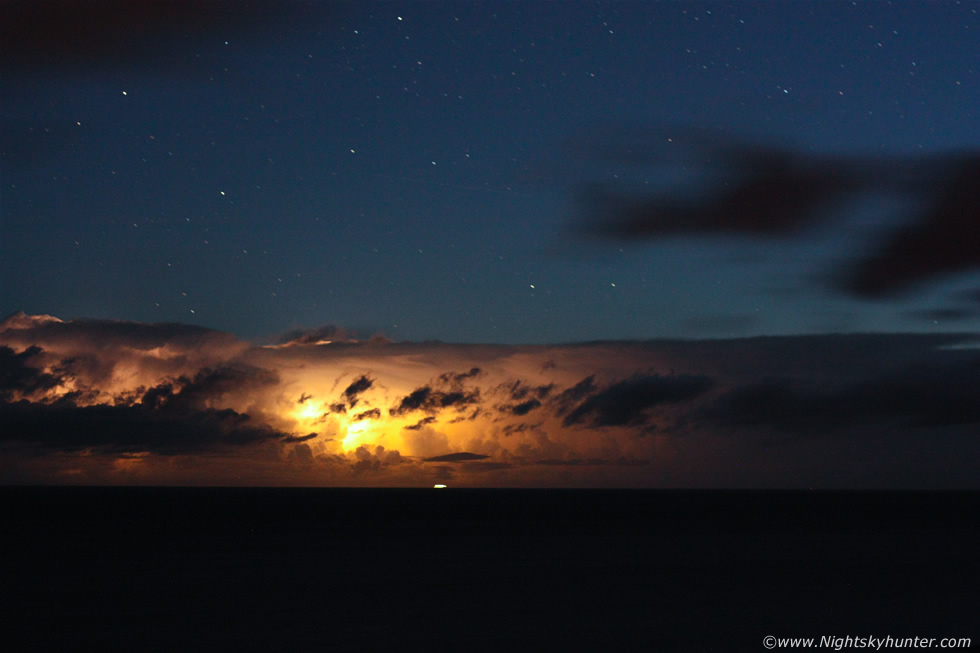
One of the few shots without lightning, I had to post this to show you the difference, this is the before frame and below is the after. With the naked eye all we could see was stars and darkness then suddenly bright lightning lit everything up revealing the structures, these two images would have made a great animated gif if I knew how to make them.
 |
Same scene with lightning. We observed almost every kind of lightning, in-cloud, cloud to ground, magnificent anvil crawlers (spider lightning), cloud to air, cloud to cloud and what looked like positive bolts, these bolts differed from lightning within and below the cells in that they struck the ocean from the top of the anvil from a great height, these kind of bolts have a lot of energy and are extremely dangerous.
 |
Crop from the above image. Most of the lightning was orange and yellow in colour however on occasion we could see white bolts which had a tendency to turn the top of the storm a pearly white colour which also turned the sky a deep blue tone. I was counting every flash of lightning to get an accurate count and after the 200 mark we were laughing out loud in disbelief as more flashes lit up the ocean and so the count continued. Two amazing visual scenes will forever stay imprinted in my mind, one was seeing lightning illuminating a formation of mammatus under the anvil which seemed to glow yellow in colour then suddenly plunge into darkness, the next was seeing overshooting tops lit up by bolts which gave the effect of a searing white bump on top of the storm with sharp bolts jetting out sideways into the air, this mental image with stars above was simply breathtaking and this wasn't a one off either, the same thing happened several times.
 |
I think Paul and I were causing quite a scene because every time there was a flash we shouted with joy, all one could hear from us was yells of excitement, wows, my God, my goodness, holy c**p and other curse words, we just couldn't contain ourselves, it was a good job that priest didn't come back out for another walk, he may have heard something unsuitable for his ears!. We drew attention from our constant yelling because cars suddenly appeared to check us out and once they realised why we were shouting they too pulled over, switched off their lights and watched the show.
 |
Two storms sparking at the same time and we had regular overshooting tops in view which was pretty awesome. This was beyond luck, not only where the storms a frenzy of lightning activity but add to that the view with stars around the storms and the fact that we didn't have a drop of rain on us so we could shoot the entire scene without distraction, plus add in the bonus of no dangers from strikes at this range and you have a very rare and perfect moment, I've waited seven years to experience an event like this from Ireland, I missed three night lightning events over Antrim last week despite being out in the middle of the night trying due to heavy rain, cloud cover and bad positioning, however it was worth missing those to experience this magnificent spectacle.
 |
This was like watching nature's artillery fire during an epic ocean battle, a large cluster of lightning flashes involving i-c bolts, c-gs and giant anvil crawlers all ripping across the storm for a vast distance lasting for several seconds, here they are all in unison in the one image which reminds me of a vast ship over the sea lit from within. Check out the new dark updraught tower which shot up at the rear of the storm in clear air where it can grow on its own and not be in competition with other cells.
 |
At this stage I was getting a dry throat from all the shouting I was doing and was having trouble keeping count of the lightning. Night lightning is fairly rare in Ireland so storm photographers in this country don't get much chance to practice photography of this nature very often other than what one reads online, however getting a chance to put it into practice is something else entirely. However if you do a lot of astronomical photography like we do then it becomes second nature. It was just a matter of selecting the correct lens, in my case I used the very fast 50mm F/1.8 which I left wide open at full darkness to collect as much light as possible which would enable me to use shorter exposures and hence reduce cloud motion blur, this worked a charm, the ISO was at 1600 and exposures ranged from 7 sec's to 20 sec's depending on how bright or dark the background sky was. There was that much activity that it would be difficult to get images without lightning which is not something one can often say in this country.
 |
Crop from the above image. Thank goodness we trusted our instincts and stuck it out otherwise we could have easily become a victim to temptation and leave at sunset for the drive home, this was our reward from nature, not only from today but from all the other days over the last week and a half we have spent in various parts of the country hunting storms and I have to tell you it was a tremendous feeling of triumph and satisfaction.
 |
Check out the overshooting top on that cell and the solid rounded form to the dark anvil sailing in behind the primary cell. This was another episode of in-cloud and crawler bolts lashing through the storm clouds from within, we could never have got tired of watching that happen.
 |
I have to say that the night sky above these storms was exquisite, in fact, the darkness and rich structure to the dust clouds within the Milky Way was so remarkable that we actually left the storms alone for a few min's to take it all in, the sky was perfectly clean and transparent, it was as if the storms had cleaned away all the haze and gunge and turned the heavens into a transparent dome, it was amazing, we also kept seeing many meteors from various radiants including several early Perseids, a couple of which burnt up above the flashing storms, it was all happening this night.
 |
When I saw those features above the cells I mistakenly thought they were red sprites or a related upper atmospheric lightning phenomena however I was informed by experts that they were not sprites and more likely cloud illuminated by lightning, the features are too low in the atmosphere to be sprites and even if they did come from storms further away beyond this one it still was not high enough in the atmosphere, I was hardly disappointed, I have just added them to my dream list and will try for sprites again, perhaps over ocean storms in the Winter period.
 |
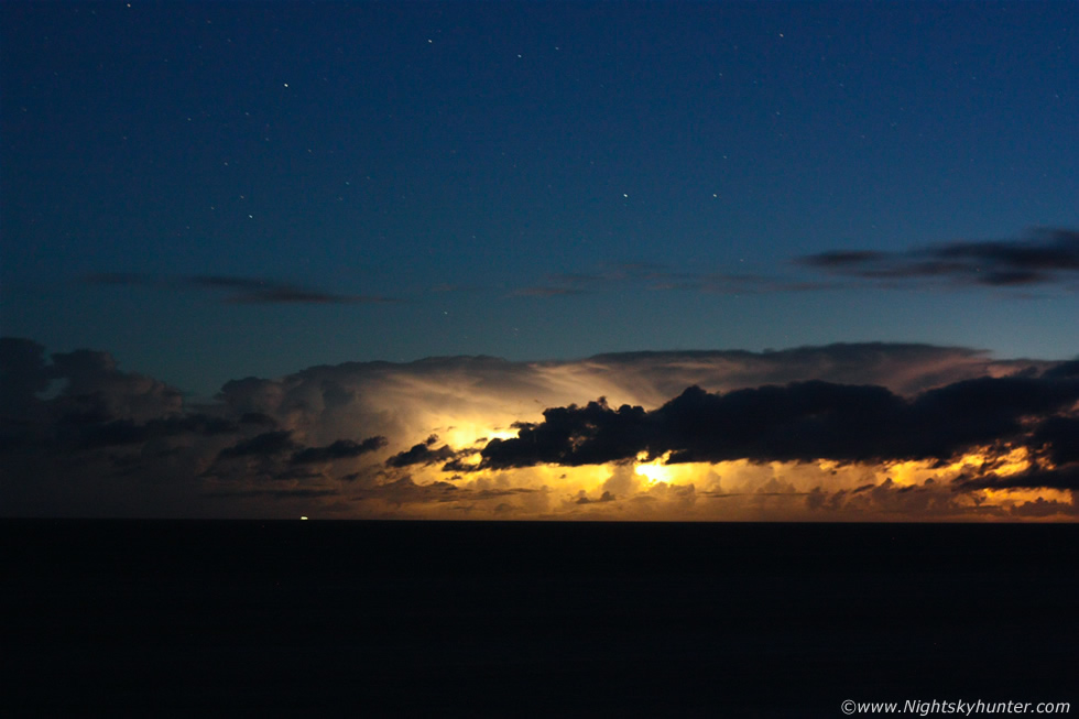
Look carefully at this stunning new cell at the rear of the complex which has now become the dominant storm in the area with a long duration overshooting top and rounded anvil.
 |
Now look at it, this is perhaps one of my favourite images from the entire shoot. The new storm is lit up like a Christmas tree by multiple lightning bolts which reveal a well defined back sheared anvil, a pronounced overshooting top and flanking towers, you can see bolts very clearly appearing from high up in the storm, both shooting from the rear and side of the anvil into the air, these are cloud to air bolts and the first of this kind I have ever captured on camera. Judging by the structure, the persistent overshooting top, lightning frequency and the kind of highly sheared environment this storm was feeding from I suspect that this could have been a supercell thunderstorm, and I would hazard a guess that there where several supercells in this area.
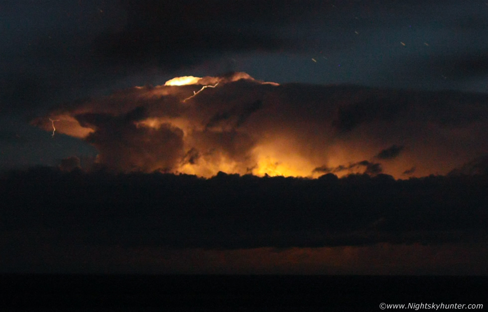 |
Close crop of the same image showing the bolts and that remarkable overshooting top which was lit up like a light bulb. I vividly remember seconds after this seeing another bolt actually shoot through the top itself which was another tick in the 'rare sights' list. A long lasting overshooting top is often a good visual indicator of a severe storm which is highly capable of or in the process of producing a tornado and severe weather at ground level. A typical updraught tower climbs skyward until it reaches the Tropopause - the invisible ceiling or lid at the top of the Troposphere where all our weather takes place. Once an updraught hits the Tropopause it spreads out forming the storm's distinctive anvil. However extremely powerful updraughts can punch through the Tropopause and enter the higher Stratosphere where they can encounter powerful upper level winds in the jet stream which can cause major shearing of the tower and greatly increase the storm's longevity and organisational capabilities. We had been seeing overshooting tops on several storms this night already however the overshooter on this storm was the most impressive of them all.
 |
Later the same cell really was lit up like a light bulb, the entire storm almost blew out due to the brilliance of these bolts. I stopped counting after observing 500 lightning bolts, I will repeat that just so you know I didn't make a typo - that's 500 bolts!!!, and to think that this line of storms had been producing lightning all day long since 07.00 and was still going is a testament to their incredibly long life cycles and severity. Had these storms been 200 miles further E they would have crossed over the country all night long and would have caused major problems, perhaps we may have dodged a bullet with these cells. We had been taking images non stop for over two hours now so we decided to stop and just take in the visual scene for the memory. Paul and I stood in silence from this remote location watching the lightning show performing against a black sky among a sea of stars with zipping meteors and a Milky Way which looked like a visual CCD image, this is what it's all about, living for the moment and being part of something very special that we might never see again.
 |
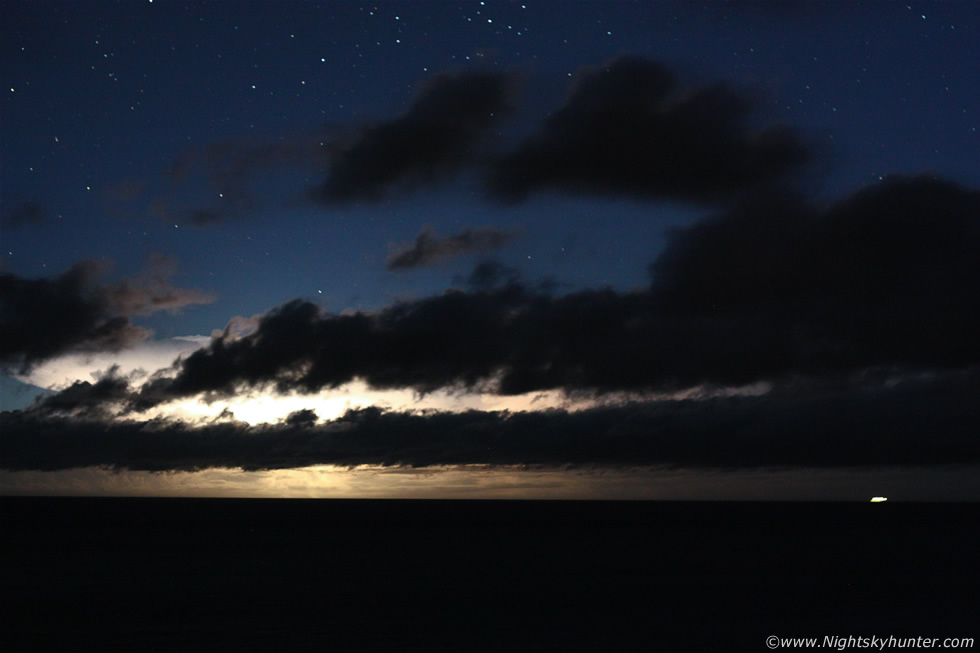
I had to include this 10mm image for the memory showing the northern sky with sweeping clouds lit by distant lights, the white area is from another flash of lightning, this time from over the north coast of N. Ireland where the leading cells of that train had now migrated. We packed up the gear and watched from the car as a new cell went up and started flashing near Donegal however we decided to let it go as we were more than content with what we got so we began the long journey home, every now and then a flash would break up the serenity of the night sky which just added to the thrilling atmosphere.
I have to say it was an extremely tough journey home, during the hours of shooting we were experiencing unbelievable thrills and excitement however once the adrenalin wore off it felt like every ounce of energy had left my body and that I was running on an empty tank with no internal fuel left, I was just heavy, numb, tired, dehydrated and I felt like my body was light and experiencing a living dream, this long photo shoot and the other chases from the previous week had finally caught up with me and for the first time ever I was getting slightly concerned for our safety on the road as my brain was just not thinking clearly at all. Paul was wrecked too so instead of sitting quiet in a half-sleep state we struck up a chat about the night and relived those magnificent bolts and this alone seemed to generate new adrenalin which kept me focused on the road. In Omagh Paul made me another brew then I did a few press ups and stretching exercises which got the blood pumping and made me feel wide awake again. The final journey home seemed long however I was feeling fresh again and besides, how could I not enjoy the late night road journey with brilliant stars for company?, when leaving Tobermore I saw another brilliant lightning flash away over the N coast, it amazed me that those storms were still throwing out sparks. I arrived home at 04.15 and was in bed for 05.30, I had been awake for over 22 hours. Between us over the last week we had traveled 1175 miles storm chasing and spent over £180 on fuel and food so it had certainly been an action packed, time consuming and expensive period of weather photography.
Here's a youtube video slideshow I made showing a selection of images in the correct sequence with 2.5 sec's between each image which I hope will give you some hint to how electrically active these storms were, I hope you enjoy it and make sure to turn your volume up.
The next morning I checked Sat24 and was amazed to see that those storms were still producing lightning and by now had traveled into the N Atlantic hundreds of miles to the W of Scotland which is an impressive feat indeed, I can only imagine the amount of sferics these storms actually produced in the last 24 hours. I even went chasing today despite trying to talk myself out of it and met a thundery shower over Antrim which had no structure and which was displaying 7 lightning flashes and I just burst out laughing, it was difficult to get impressed after experiencing the show of a life time last night. I have to admit that I was buzzing for days after last night's event and every night since I have been dreaming of lightning which shows the kind of impact it had on me. I would just like to think Mother nature for rewarding all our efforts with this remarkable show which made up for the bust days and which gave us the thunderstorm fix we needed this year so if nothing else weather related happens this year then I can feel happy and content with what I have experienced. I hope you enjoyed the report and images and don't forget to check out Paul's image report to see his excellent images and read his side of the story. Thanks very much for reading.
Martin McKenna